Your Consultative Signs and Graphics Partner for Eastside Businesses


Overlake Business Park Wayfinding Solutions: A Buyer’s Guide
Sep 26, 2026 by Signarama Redmond

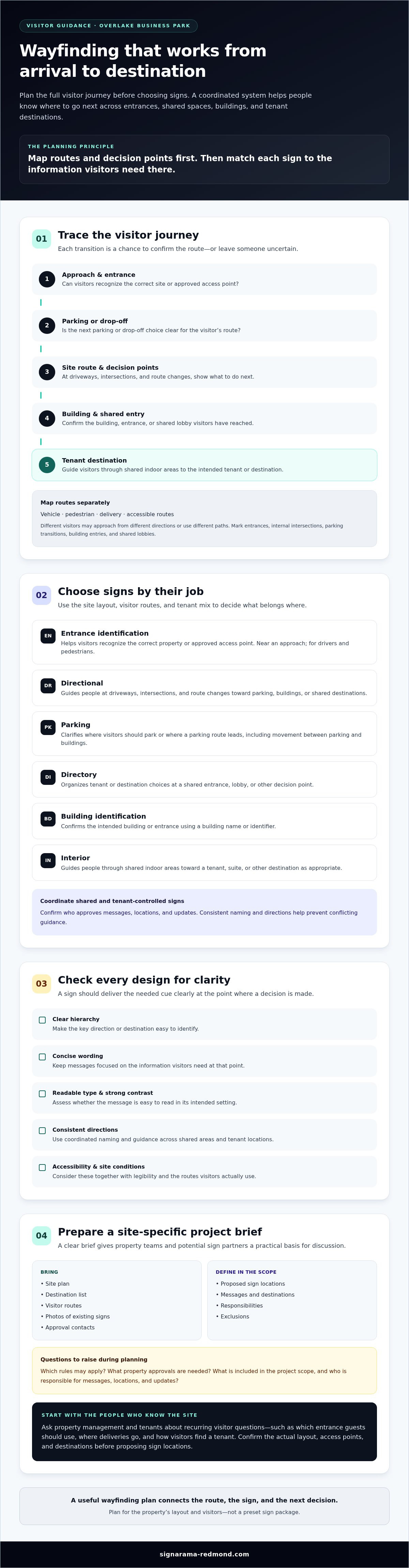
What if the hardest part of a visit to Overlake Business Park isn’t finding the address, but knowing which entrance, building, or tenant destination comes next? Overlake business park wayfinding solutions work best when signs guide visitors through the full journey, rather than treating each sign as a separate decision. Clear directions matter when multiple tenants, shared spaces, and property approvals are involved.
This guide explains how to plan and evaluate signs from arrival to destination. You’ll learn how to map decision points, coordinate signs for common areas and tenant locations, and weigh legibility, accessibility, and site conditions together. We’ll also cover questions to raise about applicable rules, property approvals, project scope, and responsibilities. With a clear brief, you can compare potential sign partners and plan next steps with greater confidence.
Key Takeaways
Map how visitors move from arrival to each destination before deciding where signs should go.
Compare entrance, directional, parking, directory, building identification, and interior signs by the job each needs to do.
Assess designs for clear hierarchy, concise wording, readable type, strong contrast, and consistent directions.
Evaluate Overlake business park wayfinding solutions by asking for a site-specific scope that identifies sign locations, messages, responsibilities, and exclusions.
Gather a site plan, destination list, visitor routes, existing sign photos, and approval contacts before project discussions.
Table of Contents
Overlake Business Park wayfinding: map the visitor journey before choosing signs
Which Overlake wayfinding signs should your property consider?
How to evaluate Overlake wayfinding designs for clarity and accessibility
How to compare wayfinding providers and plan an Overlake project
Start an Overlake business park wayfinding project with clear next steps
Overlake Business Park wayfinding: map the visitor journey before choosing signs
A visitor shouldn’t have to guess which driveway to enter, where to park, or which building contains their destination. Before choosing signs, trace the trip from arrival to endpoint. A visitor might approach by vehicle, find parking or a drop-off area, enter the site, locate a building, then follow directions to a shared lobby or tenant destination. Each transition is a chance to confirm the route or leave someone uncertain.
Wayfinding combines the decisions people make as they navigate with the cues that help them make those decisions. A sign plan applies this through a coordinated mix of directional, identification, and confirmation signs. In practical terms, wayfinding is coordinated guidance that helps people move from arrival to their intended destination. For a high-level overview of the concept, see wayfinding.
Where do visitors get lost on an Overlake site?
Start with routes, not sign styles. Map vehicle, pedestrian, delivery, and accessible routes separately, since each group may approach from a different direction or use a different path. Mark decision points such as site entrances, internal intersections, parking transitions, building entries, and shared lobbies. These are the places where visitors need a clear cue about what to do next.
Ask property management and tenants to note recurring questions: Which entrance should guests use? Where do deliveries go? How do visitors find a particular tenant? Their answers can reveal gaps a site walk alone may miss. Confirm the property’s actual layout, access points, and tenant destinations before proposing sign locations. A plan that works for one property may not fit another.
What belongs in a business-park wayfinding system?
Consider signs by the information they provide along the route:
Entrance identification helps visitors recognize that they’ve reached the correct site or access point.
Directional signs guide people at driveways, intersections, and route changes.
Directories help visitors identify a tenant or destination when several choices share a location.
Destination identification confirms that a visitor has reached the correct building, entrance, or tenant area.
Not every property needs the same combination or placement. The site layout and tenant mix determine where guidance is needed and what information belongs on each sign. Separate shared-property signs from tenant-controlled signs, then confirm who approves messages, locations, and updates. This coordination helps prevent conflicting directions or inconsistent naming. A visitor-journey map gives property teams and a potential signs and graphics partner a practical starting point for discussing Overlake business park wayfinding solutions and defining the project scope.
Which Overlake wayfinding signs should your property consider?
The right sign mix depends on what visitors need to know at each point, where they need that information, and who uses the route. A driver approaching a property needs different guidance from a pedestrian looking for a tenant inside a shared building. Use the categories below as a planning checklist, not a preset package. Confirm the property layout, visitor routes, and responsibilities before deciding what belongs in the final plan.
Sign category | Purpose and likely placement | Audience and information |
|---|---|---|
Entrance | Identify the property or an approved access point near an approach. | Drivers and pedestrians; property name or entrance identification. |
Directional | Guide people at driveways, intersections, and route changes. | Drivers or pedestrians; concise directions to parking, buildings, or shared destinations. |
Parking | Clarify where visitors should park or where a parking route leads. | Drivers and people moving between parking and buildings; relevant parking locations or directions. |
Directory | Organize destinations at a shared entrance, lobby, or other decision point. | Visitors seeking a tenant, business, or destination. |
Building identification | Confirm the visitor has reached the intended building or entrance. | Drivers and pedestrians; building name or identifier. |
Interior | Guide visitors through shared indoor areas to the final destination. | People inside the building; tenant, suite, or destination information as appropriate. |
How should you prioritize signs by location?
Start with decision points where visitors must choose a direction or entrance. Separate vehicle-facing information from pedestrian guidance and indoor directions so each message serves the right audience. During an onsite review, check sightlines, viewing distance, lighting, and visual clutter. A sign may be easy to miss if it appears after a turn or blends into a busy view. Confirm the final placement and sign type against actual site conditions.
How do tenant directories and identification signs fit together?
A directory helps visitors find a tenant name; directional signs then help them reach the right building or area. Building and interior identification signs can confirm the destination along the way. Before planning these signs, assign responsibility for supplying, approving, and updating tenant names, suite details, and directory content. For building interiors and tenant identification, explore professional office signs in Redmond.
Property responsibilities, routes, and site conditions shape the final mix, so don’t assume every category is needed. A site-specific discussion can clarify which signs and graphics fit the project and which scope details, approvals, or responsibilities need confirmation.
How to evaluate Overlake wayfinding designs for clarity and accessibility
A visually attractive sign isn’t automatically easy to navigate by. For Overlake business park wayfinding solutions, judge the design by whether visitors can notice the sign, understand its message, and follow consistent route logic from one decision point to the next. Review proposed signs in the context where people will encounter them, not only on a screen or sample page.
Legibility depends on the message, viewing conditions, placement, and the needs of people using the route. Check whether the most important information stands out, the wording is concise, and the type can be read from the expected viewing distance. Consider contrast alongside lighting, sightlines, and visual clutter. Keep destination names, arrows, and directional language consistent throughout the journey.
What makes a wayfinding sign easy to understand?
Give each decision point one clear next step. For example, a sign at an intersection should make the relevant destination and direction easy to pick out, rather than asking visitors to sort through unrelated details. Use the same name for a destination on entrance signs, directories, and interior guidance. Check that arrows point toward the route they describe and that signs appear before visitors need to act.
Review draft messages with people unfamiliar with the property. Ask them to follow a route using the proposed sign sequence, then note where they hesitate, misread a direction, or expect another cue. Revise unclear wording or placement and test again. This review can reveal problems that a team familiar with the site may overlook.
How should buyers check accessibility and local rules?
Treat accessibility as a required part of design review, not a final adjustment. Verify which provisions of the ADA Standards for Accessible Design apply to each sign type and location. Requirements can depend on a sign’s purpose and context, so don’t assume one rule covers every sign. Ask the City of Redmond and property management which current local rules and property-specific approval steps apply. Confirm requirements before finalizing sign messages, locations, or scope. Don’t assume a permit is either required or unnecessary.
Include installation planning in that review. A proposed location may affect visibility, route access, or whether a sign can be read as intended, so ask who will confirm the final placement and who is responsible for approvals and installation. For a related reference, see professional sign installation in Redmond, and verify directly which project responsibilities and capabilities apply to your site.
How to compare wayfinding providers and plan an Overlake project
A useful provider conversation turns visitor routes, tenant needs, and property requirements into a clear, reviewable scope. Compare proposals by how well they explain the work and responsibilities, not just how they present the signs. For Overlake business park wayfinding solutions, verify each claimed capability and confirm what’s included before making a decision.
Define users. List who needs directions, such as visitors, employees, delivery drivers, and people moving through shared areas.
Map routes. Mark arrival points, entrances, parking transitions, intersections, buildings, and final destinations.
Confirm approvals. Identify property-management and tenant reviewers, and check which City of Redmond or property-specific rules may apply.
Compare proposals. Review sign locations, messages, responsibilities, exclusions, and assumptions about site conditions.
Plan updates. Agree how tenant changes, directory edits, and future revisions will be handled.
What questions should you ask before choosing a sign partner?
Ask how the provider will learn the site’s routes, decision points, tenant needs, and property-management requirements. Clarify which tasks are included and who is responsible for design approvals, code checks, signs and graphics, site coordination, and installation. Don’t assume a provider handles every stage. Request examples of relevant work if available, and ask for enough detail to understand how they relate to your project.
What should a useful wayfinding proposal include?
Request a site-specific scope with a sign schedule, proposed locations, messages, and a clear responsibility list. It should identify exclusions and state what information or approvals are still needed. Check whether the proposal explains how revisions will be reviewed and how tenant changes, maintenance, and directory updates may be addressed. If these items aren’t defined, ask who will handle them and whether they fall within the proposed scope.
Before authorizing production, document open questions and approval dependencies. Confirm whether site conditions, sign specifications, or property review could affect the scope. Costs depend on the confirmed project scope, site conditions, and selected specifications, so compare proposals only after checking that they describe comparable work.
If you’re ready to discuss your sign requirements and clarify the proposed scope, contact Signarama about your project.
Start an Overlake business park wayfinding project with clear next steps
A focused project brief helps property management, tenants, and a potential signs and graphics provider work from the same information. Before discussing Overlake business park wayfinding solutions, gather the basics, note what still needs confirmation, and identify who can make or approve project decisions.
What information should you prepare for an initial discussion?
Use this checklist to organize a shared starting point:
Site plan: Mark entrances, buildings, parking areas, and shared spaces.
Destination list: Include tenant names, building identifiers, and any destinations visitors need to find.
Visitor routes: Note common paths from arrival and parking to building entrances and destinations.
Current sign photos: Capture existing signs and note any that are hard to see, outdated, or unclear.
Known navigation issues: Record recurring visitor questions, access changes, or planned property updates.
Contacts and open questions: Identify property-management and tenant decision-makers, and list accessibility, property-rule, or City of Redmond requirements that need verification.
This information can help a provider understand the request, but don’t assume every project task is included. Confirm directly whether the provider can address the requested sign and graphics scope, and clarify who is responsible for review, approvals, production, and installation. Verify any capability that hasn’t been established before treating it as available.
How can property teams keep the system useful over time?
Plan for changes as well as initial sign decisions. Assign someone to maintain accurate directory information, communicate tenant or suite changes, report damaged or outdated signs, and arrange routine reviews. Clear ownership can prevent old names or directions from lingering after a business moves or a route changes.
Keep destination names and directional wording consistent across shared and tenant-controlled signs. When site access or tenant locations change, review the full route so a revised message in one place doesn’t conflict with directions elsewhere. Ask the provider what follow-up work, if any, is within the agreed scope and what the property team will manage.
Before moving ahead, share the brief with property management and affected tenants, then document open questions, approval contacts, and agreed responsibilities. Discuss the project scope and next steps directly with a provider so both sides can confirm what the work includes. To start that conversation, discuss your wayfinding sign project.
Move forward with a clearer wayfinding plan
Good Overlake business park wayfinding solutions start with the visitor’s full trip, then connect each sign to a clear purpose, location, and responsible decision-maker. A mapped route, consistent destination names, and a site-specific scope give property teams and tenants a practical basis for reviewing sign choices together.
Before committing, confirm applicable accessibility and property requirements, approval steps, and who is responsible for each part of the project. Signarama offers signs and graphics. Discuss specific wayfinding needs and project responsibilities directly rather than assuming they are included.
Bring your site plan, destination list, existing sign photos, and open questions to a planning conversation. Discuss your wayfinding sign project and clarify the scope and next steps that may fit your property. Use that conversation to confirm what the project includes and who will handle each part.
Frequently Asked Questions
What wayfinding signs does an Overlake business park need?
The right sign mix depends on the property’s entrances, destinations, visitor routes, and existing signs. Directional signs, directories, parking guidance, and building identification may all be useful, but they aren’t a fixed package for every site. Start by reviewing how people move through the property, then ask property management and tenant representatives where visitors need help. Their input can guide which sign types to consider and where to assess them.
Do I need a permit for business park wayfinding signs in Redmond?
There isn’t a universal yes-or-no answer. Requirements can depend on the sign type, size, placement, property rules, and current local code. Before signs are produced or installed, verify the specific proposal with the City of Redmond and property management. Ask which requirements and approval steps apply to the planned locations and sign types. Check current rules directly rather than relying on an assumption based on a different project.
How do you make business park wayfinding signs accessible?
Use readable messages, clear directional logic, and guidance that connects to accessible routes. Then verify which ADA Standards for Accessible Design provisions and local requirements apply to each sign type and location. Requirements may differ based on a sign’s function and where it’s placed, so a generic checklist may not address the project. Review applicable standards and proposed locations with the project team before signs are produced or installed.
Which signs help visitors find a tenant in a large business park?
Entrance signs, directional signs, tenant directories, and building or suite identification can work together to guide visitors. A directory can identify a tenant, while directions at decision points help people continue to the right building or entrance. Keep destination names consistent throughout the route so visitors aren’t left wondering whether different labels refer to the same place. The best combination depends on the property layout, visitor routes, and existing sign system.
How should I compare wayfinding sign proposals?
Compare proposals by their site-specific sign schedule, suggested locations and messages, design review, approval responsibilities, installation scope, and plan for updates. Ask what’s included and excluded, and confirm claims about the provider’s capabilities rather than assuming every project task is covered. Check that proposals describe comparable work and specifications before assessing them side by side. Clear responsibility boundaries help property teams understand what decisions and coordination remain theirs.
Can one wayfinding system serve visitors, tenants, and delivery drivers?
A coordinated system can support different audiences if their routes and destinations are mapped separately. Drivers may need directions to an entrance or parking area, while pedestrians and delivery drivers may follow different paths or need different information. Map these journeys before deciding where signs belong. Involve property management and tenant representatives to identify shared needs, clarify responsibilities, and reduce the chance that signs provide conflicting directions.
When should a business park update its wayfinding signs?
Review signs when tenants or building names change, entrances or routes shift, access conditions are updated, or users report recurring confusion. Assign responsibility for checking directory accuracy and sign condition so outdated information can be flagged. Review timing depends on site operations and the changes taking place. Before revising signs, confirm that proposed updates align with current property approvals and applicable requirements, checking with the relevant contacts as needed.


Signarama Redmond, WA
Summer Hours (July - August) - MON-THUR: 8.00AM - 6.30PM, FRI - SUN: CLOSED
contact
Signarama Redmond, WA